The Fang

Activities
Vail, 81657

Do you own or operate The Fang? Claim this listing now. Claim this listing

About

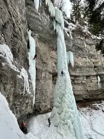
The Fang is a free-hanging pillar of ice, well over 100 feet tall, that forms in some winters in the Rigid Designator Amphitheatre, a north-facing cliff band in East Vail on the south side of the valley, above the east end of the Vail Golf Course and opposite Booth Creek. When it touches down it is a celebrated ice climb, graded WI5-6, which is expert terrain.

For most visitors the Fang is something to look at rather than visit: the amphitheatre is easy to see from the road below. For experienced ice climbers it is a serious objective that does not form every season, and anyone without that experience should go with a professional guide or not at all.

Contact Information

Company Name
The Fang
Location
The Fang ice climb, east of the Vail Golf Course (Aspen Court trailhead)
Vail, 81657

The Fang Photo Albums


The Fang Photos
The Fang Photos

Photos of The Fang.... View More


We may earn a commission from links on this page, at no cost to you. Disclosure

About The Fang

Quick answer: The Fang is a business at The Fang ice climb, east of the Vail Golf Course (Aspen Court trailhead), Vail, CO 81657. The Fang, East Vail's famous free-hanging ice pillar in the Rigid Designator Amphitheatre: a WI5 expert ice climb that forms in some winters.

Last updated

The Fang is a free-hanging pillar of ice, well over 100 feet tall, that forms in some winters in the Rigid Designator Amphitheatre, a north-facing cliff band in East Vail on the south side of the valley, above the east end of the Vail Golf Course and opposite Booth Creek. When it touches down it is a celebrated ice climb, graded WI5-6, which is expert terrain.

For most visitors the Fang is something to look at rather than visit: the amphitheatre is easy to see from the road below. For experienced ice climbers it is a serious objective that does not form every season, and anyone without that experience should go with a professional guide or not at all.


Frequently Asked Questions

Where is the Fang?
In the Rigid Designator Amphitheatre in East Vail: a north-facing cliff band on the south side of the valley, above the east end of the Vail Golf Course and directly opposite Booth Creek. The amphitheatre sits at about 8,855 feet. It is a valley-side ice feature in East Vail, not part of the Vail Mountain ski area.
Can I see the Fang without climbing it?
Yes, and that is how most people experience it. The amphitheatre is easy to see from the road below, and in a winter when the pillar has formed it is visible as a hanging column of ice on the cliff band above the golf course. The climbers' approach trail is not a sightseeing walk: it climbs a slope that can avalanche to the base of an ice cliff where ice falls, so viewing from the valley floor is the right call for non-climbers.
How hard is the climb?
The Fang is graded WI5-6, expert waterfall-ice terrain. The bottom is usually heavily cauliflowered and hard to protect with ice screws; the upper section is vertical to overhanging ice. Climbers lower or rappel from the top using two ropes.
When does it form?
In winter, and not every year. It once formed only once every five years or so; it forms more consistently now, but it usually touches down later than the neighboring Rigid Designator, and it can form thin and fall down several times before it thickens. Because it never sees the sun, the ice that does form tends to persist. Whether it is in condition in any given week is a matter of current local reports, not a calendar.
Is it safe?
It carries real, documented risk. The Fang has been known to fail completely with a climber on it, snow on the approach can avalanche, and rappel trees in the area have occasionally failed. Anyone without expert ice-climbing experience should go with a professional guide or not at all.
Where do climbers park?
The Town of Vail does not allow on-street parking, so find a legal parking spot and expect to walk. The approach described by Mountain Project starts from the Pumphouse parking area side: east along the Frontage Road to Aspen Lane, then Aspen Court, where a trailhead at the end of the cul-de-sac gives access across the golf course.
How do I get to the base, and how long is the approach?
From the Aspen Court trailhead, cross Gore Creek on a footbridge and turn left (east) onto the signed climbers' trail. It crosses the Vail Golf Course to the right of the groomed cross-country track (walk beside the track, not on it), then leaves the valley floor in a rising traverse into the drainage below the wall, gaining about 550 feet to the base of the Designator and the Fang.
How tall is the Fang?
Sources differ, and its size changes from year to year. Mountain Project describes about 120 feet of free-hanging ice (its own route header and area list give 130-135 feet), while Wikipedia gives 165 feet tall and 26 feet wide. Any single figure is a snapshot of one source or one season.
Who first climbed it?
Alex Lowe, in 1981. The same wall later became famous a second time when Jeff Lowe made the first ascent of Octopussy, the mixed route often credited as the start of modern mixed climbing in Colorado.
Is The Fang a ski run or a hiking trail?
Neither. It is not on Vail Mountain, no lift serves it, and it has no resort trail designation or grooming; and the footpath to it is an unmaintained climbers' trail to the base of an ice cliff, not a hiking trail. It is a seasonal frozen waterfall that expert ice climbers climb in winter and everyone else sees from the valley floor.