
Vail Pass summits at 10,662 feet in the southern Gore Range, where Interstate 70 crosses between Vail and Summit County. The town of Vail sits at about 8,150 feet, so the interstate climbs roughly 2,500 feet in the 14 miles from Vail's main exit (176) to the Vail Pass exit (190). The interstate over the pass is the main road from Vail to Frisco, Breckenridge and Keystone, so its traction rules and construction zone matter to anyone driving that way. The pass is also a trailhead: a paved path, two fishing lakes and a 55,000-acre winter recreation area all start here.
How high is Vail Pass?
Vail Pass summits at 10,662 feet on Interstate 70, at exit 190, in the southern Gore Range between Vail and Frisco. That is about 2,500 feet above the town of Vail, 14 miles to the west, and about 900 feet below the 11,570-foot top of Vail Mountain's lifts. The pass is named for Charles Vail, a state highway engineer.
| Detail | Fact |
|---|---|
| Summit elevation | 10,662 feet |
| Town of Vail elevation | About 8,150 feet (Vail Mountain's base: 8,120 feet) |
| Location | Southern Gore Range, on I-70 between Vail and Frisco |
| Named for | Charles Vail, Colorado state highway engineer |
| Paved road over the pass | Completed 1940, as part of US 6 |
| Interstate 70 over the pass | Completed 1978 |
| Rest area | Exit 190; rebuilt and reopened by CDOT in September 2025 |
| Construction zone | East Vail interchange (mile point 180) to the Vail Pass Rest Area (mile point 190), due to finish by the end of 2026 |
Pass elevation and road dates are from the Colorado Encyclopedia; the town figure is the Town of Vail's; the rest area and construction details are from CDOT.
Vail's 8,150-foot figure is the elevation of Gore Creek just east of the International Bridge in Vail Village. The ski mountain runs from its 8,120-foot base to 11,570 feet at the top, so the top of the lifts sits about 900 feet above the pass.
When was the road over Vail Pass built?
The first paved road over Vail Pass opened in 1940, a two-lane highway built with federal Public Works Administration money that became part of US 6. Interstate 70 replaced it and was completed over the pass in 1978, raised on a viaduct in places. People were camping on the pass at least 8,000 years ago.
People were camping here long before anyone drove over it. Vail Pass Camp, an archaeological site about 220 yards west of I-70 near the present rest area, records occupation stretching back at least 8,000 years, and its most recent use was probably a Ute camp in the mid-1700s.
Modern roads arrived late. Until the 1930s the Gore Range was a barrier: the earliest automobile roads west from Denver turned north to Steamboat Springs or south to Leadville to avoid it. Boosters in Red Cliff began pressing the state in the 1920s for a "Holy Cross Trail" along roughly the route I-70 would later take, and a dirt road reached Red Cliff by way of Shrine Pass in 1931 but was never paved. In 1940 the state used federal Public Works Administration money to pave a two-lane road over Vail Pass, between West Ten Mile Creek and Black Gore Creek. It became part of US 6, took the name of state highway engineer Charles Vail, and gained a reputation as one of Colorado's most dangerous roads.
The US 6 corridor was chosen for I-70 in 1960. Planners first hoped to skip the pass altogether with a tunnel under the Gore Range near Red Buffalo Pass, which would have saved ten miles, but the interstate went over the top after all and was completed in 1978, raised on a viaduct in places to avoid unstable slopes. For the story behind the town's own name, see how Vail got its name.
What should you know before driving Vail Pass?
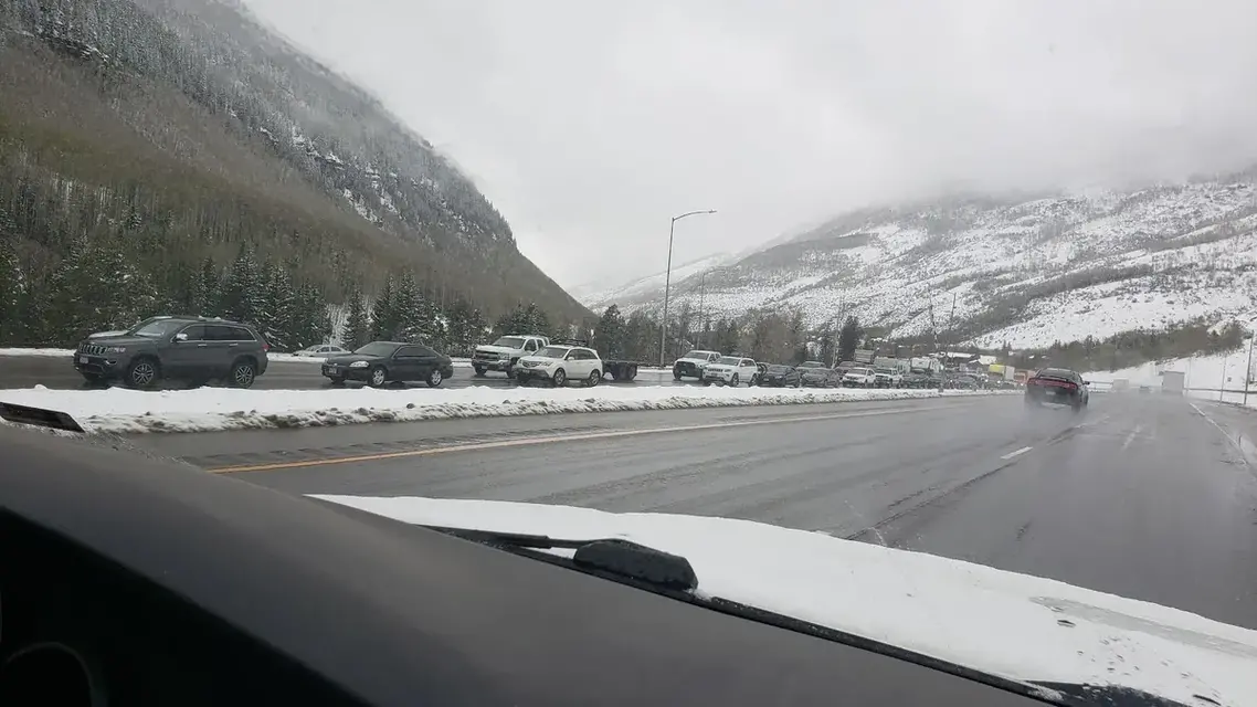
From September 1 through May 31, Colorado's Traction Law applies on I-70 over Vail Pass, and CDOT enforces it in storms: you need winter, all-weather or mud-and-snow tires with 3/16-inch tread, or chains. Severe weather or crashes can close the pass. As of September 2026, the West Vail Pass construction zone is in its final season.
- Traction Law. From September 1 through May 31, CDOT can activate the Traction Law on I-70 between Dotsero and Morrison, which includes Vail Pass, during storms or whenever conditions require, and it announces it through highway signs, COtrip.org and alerts. Under the rules updated in fall 2025, compliance depends on the tires rather than the drivetrain: winter, all-weather or mud-and-snow tires with at least 3/16-inch of tread, or chains or an approved alternative traction device. Fines apply, and they rise steeply if an unprepared vehicle blocks a travel lane. In severe storms CDOT can move to the Passenger Vehicle Chain Law, the last safety measure before the highway closes, when every vehicle must carry chains or an approved device. The details are on the CDOT traction law page.
- Closures. When conditions are beyond what the chain law can handle, or after a crash, CDOT can close I-70 over the pass. Check COtrip.org or call 511 before you set out, and be ready to wait in Vail or Frisco if the road is shut.
- Construction. The West Vail Pass Auxiliary Lanes project, under way since 2021, is in its final season; CDOT's latest project update, from April 2026, has it due to finish by the end of 2026. Through the 10-mile zone between mile points 180 and 190, CDOT has warned of daily single-lane closures, possible night work and traffic holds of about 20 minutes in each direction, longer while queues clear. Still to be finished are paving, six wildlife underpasses between mile points 187 and 190 with fencing from mile point 185, and an avalanche and rockfall protection system in The Narrows, around mile point 186, the first of its kind in Colorado. Already open are two new bridges at mile point 185.2 and a 2.7-mile eastbound climbing lane that separates slow trucks from other traffic.
- Live conditions. COtrip.org and the 511 phone line carry current closures and alerts. The project also sends text alerts: text vailpass (one word) to 21000.
If you are continuing to Summit County, see Vail to Breckenridge or Vail to Keystone.
What can you do on Vail Pass in winter?
Vail Pass is the entry to the Forest Service's 55,000-acre Vail Pass Winter Recreation Area, with more than 119 miles of trails for skiing, snowboarding, cross-country skiing, snowshoeing and snowmobiling. Everyone needs a pass, $10 a day or $65 a season, and the terrain is avalanche country, so check the avalanche forecast before you go.
The Vail Pass Winter Recreation Area, managed by the U.S. Forest Service, covers 55,000 acres with more than 119 miles of motorized and non-motorized winter trails. Skiing, snowboarding, cross-country skiing, snowshoeing and snowmobiling all happen here, and snowmobiles are not allowed in the non-motorized areas marked on the trail map.
Everyone entering needs a pass, sold seven days a week at self-pay fee stations at the trailheads: $10 per person for a day or $65 for the season. Fees run from the Saturday after Thanksgiving to mid-April, snow permitting, and over-the-snow travel is permitted from November 15 to May 20, depending on snow. Parking is at the Vail Pass Rest Area at Exit 190, on the west side of I-70, and at four lots off Highway 24 near Camp Hale. Space is limited and the lots fill quickly. The Vail Pass and Camp Hale stations take cards, and the parking areas have no restrooms or water. The area is avalanche terrain: the Forest Service advises checking the Colorado Avalanche Information Center forecast, carrying a beacon, probe and shovel, and choosing routes by current snow and weather. For a gentler winter outing, see where to snowshoe in Vail.
What can you do on Vail Pass in summer?
In summer, Vail Pass is a trailhead. The paved Vail Pass Recreation Path runs between Vail and Copper Mountain for cyclists and walkers, the rest area at exit 190 connects to the Ten Mile Canyon Trail, and the two Black Lakes offer fishing. CDOT is keeping the path open through the 2026 construction, with occasional holds.
A paved path for cyclists and walkers, the Vail Pass Recreation Path, runs between Copper Mountain and Vail, and for several miles near Vail it follows the route of old US 6. CDOT is keeping it open through the 2026 construction, with occasional trail holds and variable surface conditions in the work zone. The rebuilt rest area at Exit 190 connects to the Ten Mile Canyon Trail, and the pass is also a hiking trailhead with fishing at the two Black Lakes. To ride in town instead, see where to rent a road bike in Vail.
Can the altitude on Vail Pass make you sick?
A drive over the pass is a short exposure; where you sleep matters more. Vail Health reports that almost one in four visitors to Vail, at about 8,000 feet, gets symptoms of acute mountain sickness, usually a headache, nausea, tiredness or poor sleep that generally clears within a day or two.
Vail Health's advice is to rest, eat lightly and drink more fluids, without alcohol. How high Vail is covers the town's own elevation. If you are timing a winter drive, when Vail's snow starts helps.