
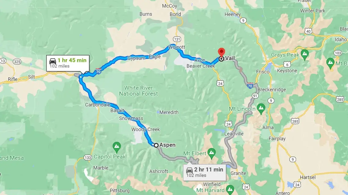
Vail and Aspen are about 100 miles apart by road, a drive of roughly two hours in good conditions. The route that works all year runs west on I-70 through Glenwood Canyon to Glenwood Springs, then south on Colorado 82 up the Roaring Fork Valley. Independence Pass has been open for the summer since May 21, 2026 and usually closes in late October or early November; it is a scenic detour by way of Leadville, not a shortcut. No passenger train runs between the two towns.
For the practical side of the trip from Aspen, including buses, private cars and a stop at Hanging Lake, see how to get from Aspen to Vail.
What are the driving routes from Vail to Aspen?
There are two. The year-round route runs west on I-70 through Glenwood Canyon to Glenwood Springs, then south on Colorado 82 to Aspen: about 100 miles and two hours. The seasonal route climbs through Leadville and over 12,095-foot Independence Pass, open from late May until about early November, and is a scenic detour rather than a shortcut.
| Route | Distance and time | Open |
|---|---|---|
| I-70 west to Glenwood Springs, then Colorado 82 south | About 100 miles and roughly 2 hours (Aspen Snowmass). Vail to Glenwood Springs is a 50-minute drive (Town of Vail); Glenwood Springs to Aspen is about an hour (RFTA). | Year-round; I-70 in Glenwood Canyon can close for crashes, rockfall or other events |
| Through Leadville and over Independence Pass (Colorado 82) | Vail to Leadville is about an hour (Town of Vail). The pass road spans 32 miles between Twin Lakes and Aspen, with the 12,095-foot summit 18 miles west of Twin Lakes. | Seasonal: closes in late October or early November, reopens the Thursday before Memorial Day; no vehicles longer than 35 feet |
The pass is a scenic detour, not a shortcut: the drive begins with an hour to Leadville before the mountain road starts. For a fixed schedule, use the I-70 route.
How long is the drive from Vail to Aspen in summer and winter?
About two hours on dry roads in either season, by I-70 and Colorado 82. In summer, Independence Pass is also open but takes longer. In winter only the I-70 route is open, and storms, the Traction Law and Glenwood Canyon closures can add time; CDOT's detour for a long canyon closure adds about two and a half hours.
Summer (late May to late October). Both routes are open. The I-70 and Colorado 82 route takes roughly two hours; Independence Pass adds the climb to Leadville and 32 miles of narrow mountain road, so allow more time and treat it as the scenic day out. Glenwood Canyon can still close for crashes, rockfall or flash-flood warnings over the Grizzly Creek burn area.
Winter (roughly November to late May). Only the I-70 route is open, since Independence Pass is gated for the season. Two hours is a dry-road figure: storms, the Traction Law and closures in Glenwood Canyon can stretch it, and CDOT's northern alternate for a long canyon closure adds about two and a half hours. Check COtrip before you leave.
What should you know about driving through Glenwood Canyon?
Glenwood Canyon is the stretch of I-70 just east of Glenwood Springs, and it is the weak point of the year-round route. CDOT closes it for crashes, rockfall and flash-flood warnings over the Grizzly Creek burn area, and for long closures recommends a northern detour through Kremmling and Steamboat Springs that adds about two and a half hours.
From Vail, head west on I-70, drive through Glenwood Canyon, and take Colorado 82 south at Glenwood Springs. CDOT calls the canyon one of the most scenic drives in the country and an essential link between Vail, Glenwood Springs and Aspen. Rest areas along the canyon include No Name, Grizzly Creek, Hanging Lake and Bair Ranch, and a recreation path beside the highway is open to walkers and cyclists. Hanging Lake needs a hiking reservation.
The trade-off is closures. Since the 2021 mudslides that cut the canyon, CDOT has closed I-70 there for safety, including during National Weather Service flash-flood warnings for the Grizzly Creek burn area, and a crash or other event can also shut the road. When a closure is expected to last more than an hour, CDOT recommends the northern alternate through Kremmling and Steamboat Springs on Colorado 9, US 40 and Colorado 13, which adds about two and a half hours. It discourages Cottonwood Pass, Hagerman Pass and Eagle/Thomasville Road as detours, since many of those roads are four-wheel-drive tracks with no cell coverage. COtrip carries closure and detour information.
From September 1 through May 31, CDOT can activate Colorado’s Traction Law on I-70 between Dotsero and Morrison whenever storms or conditions call for it, and it can do the same on Colorado 82. Under the rules updated in fall 2025, what counts is the tires rather than the drivetrain: winter, all-weather or mud-and-snow tires with at least 3/16 inch of tread, or chains or an approved traction device. The requirements are on CDOT’s traction law page.
When is Independence Pass open in 2026?
Independence Pass reopened for 2026 on May 21 at noon, according to CDOT. As of September 26, 2026, CDOT has not announced this fall's closing date. Its pass page says the road typically closes on or near November 7, weather permitting, and almost always reopens on the Thursday before Memorial Day weekend.
Independence Pass is the highest paved state highway in Colorado, crossing the Continental Divide at 12,095 feet on a narrow, curving road with steep drop-offs and some single-vehicle stretches. CDOT closes it each winter because plowing the switchbacks is unsafe and parts of the road are exposed to avalanche. The pass usually closes in late October or early November and almost always reopens on the Thursday before Memorial Day weekend.
| Year | Reopened (spring) | Winter closure that followed |
|---|---|---|
| 2021 | May 27 | October 25 |
| 2022 | May 26 | November 4 |
| 2023 | May 25 | October 30 |
| 2024 | May 31 | October 31 |
| 2025 | May 22 | November 17 (a storm closure on November 15 became the seasonal closure) |
| 2026 | May 21, at noon | Not announced as of September 26, 2026; CDOT says the pass typically closes on or near November 7 |
Source: CDOT news releases of November 17, 2025 and May 19, 2026. CDOT's pass page says it typically closes on or near November 7. A storm can close the pass earlier or delay the opening, so the dates show a pattern rather than a schedule.
Vehicles and trailers with a combined length over 35 feet are prohibited between milepost 47.2 on the Aspen side and milepost 84.2 near Twin Lakes, at all times, which rules out most RVs. Rockfall from freeze-thaw cycles is common early in the season, and cyclists share the road, so drive slowly and be ready to yield. The ghost town of Independence sits about three miles west of the summit. When the gates close, the way to Aspen from the Front Range is I-70 to Glenwood Springs and then Colorado 82.
Is there a train between Vail and Aspen?
No. Neither town has a passenger rail station. Amtrak's daily California Zephyr crosses Colorado with stops at Denver, Fraser-Winter Park, Granby, Glenwood Springs and Grand Junction; its route does not pass through Vail. Glenwood Springs is the closest the train gets to either town, and from there the trip continues by bus: RFTA to Aspen or Bustang to Vail.
How do you get from Vail to Aspen without a car?
By two public buses that meet in Glenwood Springs. Bustang's West Line runs from the Vail Transportation Center to the West Glenwood Park & Ride, and RFTA's VelociRFTA bus rapid transit covers Glenwood Springs to Aspen in about an hour. For a door-to-door trip, registered private car and taxi companies quote the transfer.
No single bus runs from Vail to Aspen, but two public services cover the pieces and meet in Glenwood Springs:
- Bustang’s West Line (Denver to Grand Junction) stops at the Vail Transportation Center and the West Glenwood Park & Ride, so it covers Vail to Glenwood Springs.
- RFTA’s VelociRFTA bus rapid transit covers Glenwood Springs to Aspen in about an hour, with buses every 12 minutes or less at peak commuter times. RFTA’s network includes a Bustang connection, and it charges fares by zone.
Private options also exist. Ascend Aspen Limo (970-239-1663), Aspen 5-Star Limo (970-309-6034), Epic Mountain Express (970-754-7433) and High Mountain Taxi (970-524-5555) are all registered to operate at Eagle County Regional Airport; the airport does not guarantee their prices or availability, so ask for a quote. The closest airport to Vail covers flying into the valley first.
Choosing between the two towns is a separate question; which is more expensive, Vail or Aspen compares costs. For bus connections, timetables and door-to-door transfers, see how to get from Aspen to Vail, and for reaching Vail itself, how to get to Vail.